I was reminded of this when Gary Embury and Lucy Ward were talking about 'Drawing Review' during the recent conference in Porto. At the end of their presentation they spoke about the forthcoming 'Bloomsbury Handbook on Drawing'. This will be a manual designed to reflect on drawing as it is used across disciplinary boundaries and cultures, in my mind it will be a survey of best practice throughout the world and as I began to think about what that might mean from my position, I began to ruminate on what I would include in it.
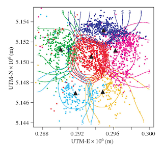
Perhaps I would start by looking at animal drawings, ones that use materials found in the world, markings made for instance to delineate boundaries. I've mentioned before how animals mark territorial boundaries, and that this is one of the most basic forms of drawing. Bears mark out the boundaries of their territory to communicate with other bears and to establish dominance. They do this in a variety of ways, some visual and some olfactory. This combination of approaches is actually the norm amongst animals and when we want to do something similar we will also use a multi sensory approach. Bears use scent glands and urine to define a boundary, but they will also use their own tracks to communicate their presence, in a similar way to how we might make a line in the sand by digging in our heels, or creating desire lines by taking the same path through a field every day. They are deliberate about where and how often they mark and they can do this to the same tree year after year, sometimes by biting and at other times by clawing through the bark.
A contemporary example would be the way we use painted lines to mark out a road system. A dashed line down the middle of the road tells drivers to keep to one side, a double dashed line tells drivers to stop and that drivers on the road they are approaching have priority. These are all aspects of territorial signalling and they work so well because as animals we intuitively recognise how boundary lines work. 'Do not cross this line of marks, if you do you will face danger!' We also use a multi sensory series of signals on the roads, for instance we will sound our horn if someone gets too close.
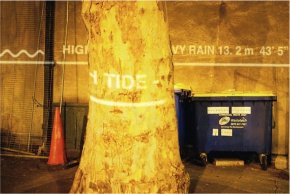
Watermarks was a public art project that used a series of projections of flood level marks on to the sides of buildings, showing how high water levels could potentially rise as global warming increases.
The Egyptians were used to the Nile flooding and they used lines strung out across the Nile valley to measure where fields might be best placed and more importantly the boundaries between each field and therefore they could also signify 'ownership'. From this stringing using a one to one correspondence with reality, was developed an early form of geometry and this included proportionality. I.e. that you could make a drawing to represent the size and shape of a field, it did not have to hold a one to one correspondence with the field. This must have been a mind blowing idea, as it meant you could go away and design ideas and make plans, for things like pyramids.
The architectural plan view, or map of a territory would therefore have been a very early thinking tool, that allowed people to represent spatial possibility. The fact that you can see the stars and their relative positions more easily because you are a long way from them, also meant that star maps would also have been developed very early on in the history of drawing. It has been argued that the oldest image that has been discovered of a star pattern, that of Orion, is 32,500 years old. A slice of mammoth tusk is carved with a man-like figure with arms and legs outstretched in the same pose as the stars of Orion.
The carved tusk fragment also has notches cut into it. It has also been argued that these could represent a "pregnancy calendar" and if so it makes us very aware of how early complex ideas could be communicated through externally visualising thought processes.
 )." by P. Utrilla, C. Mazo, M.C. Sopen, M. Martínez-Bea, and R. Domingo, which was published in the Journal of Human Evolution, 57 (2009) 99-111 is copied out below.
"An engraved block from the cave of Abauntz is interpreted as a Magdalenian map in which the actual surrounding landscape, including mountains, rivers, and ponds, is represented. Some possible routes or avenues of access to different parts of the geography are also engraved on the landscape. The engraving seems to reproduce the meandering course of a river crossing the upper part of side A of the block, joined by two tributaries near two mountains. One of these is identical to the mountain that can be seen from the cave, with herds of ibex depicted on its hillsides, on both sides of the gorge in front of which the cave of Abauntz is strategically located. In the southern part of the gorge, there is a completely flat area where the watercourses slow down, forming meanders and flooding in springtime. The following elements are also represented on the block: tangles of concentric strokes and bundles of lines forming very marked meanders. In short, all of these engravings could be a sketch or a simple map of the area around the cave. It could represent the plan for a coming hunt or perhaps a narrative story of one that had already happened. This paper is provided in the context of recent discussions on early modern human capacities of spatial awareness, planning, and organised hunting."
I realise encounters with the Western art world have shifted the use value of these traditional practices, but even so they still remind us of some of the first uses of drawing as a boundary making and mapping tool.


No comments:
Post a Comment